Cave city Calais.
the time allotted for inspection tourist facility for 2-3 hours
Getting there
From Assumption monastery
- From Assumption monastery way up the road, paved the gorge Maryam-Dere. The road leads to the foot of the plateau Calais. Access to the settlement is paid. Distance - 1 mile.
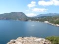
Remains of the cave city of Calais are located on the plateau of capes, on the surface
which was discovered more than a cave rooms. To lift only available east side
Cape and part of its southern slope. Settlement, which has a total area of 38 hectares, is divided into three parts, reflecting different periods of its existence: Burunchak (in translation from the Tatar "toe") - undeveloped part of the settlement - the Old Town and New Town.
According to the most common version, the fortress was founded by the Byzantines in the VI century. In VII century the fort was built around a defensive wall, which survives to this day. In the VIII century it took the Khazars.

The first written mention of the settlement under the name of Kirk-Op (Kirk-Hyères), which translated to Tatar means "forty fortresses", refer to 1299. That same year, the city seized the Golden Horde Nogai Emir. In the XV century, Kirk-Or became the capital of the Crimean Khanate, which had achieved independence from the Golden Horde. At this time the city is alive during the transition peak.
Its area was doubled by the new defensive wall erected on the eastern edge of the settlement, closing the trading quarter, inhabited by the Karaites.
In the XVI century, not far from the Kirk-Ora, in the valley Tchuruk-Su, the construction of the new capital of the Crimean Khanate - Bakhchisarai. After completion of the Muslim population left the city. Gradually the settlement was completely Karaite and became known as Calais - "Jewish fortress."
After the annexation of Crimea to Russia (1783) have left the Calais. The main reason was the removal of a ban on settlement of the Karaites in the Crimea and other cities throughout the empire.
From the foot of the mountains on the trail well nahozhennoy climb the hill to the southern entrance to the castle - Kichik Kapu, which in translation from the Tatar means "small gate."
A little aside from the path that leads to the gate Kichik Kapu, is open at the end of 1990 medieval drainage pit, called the Tick-Kuyu (translated from tatarsskogo - "straight well"); It consists of a sloping gallery, a vertical shaft and other intra-rock structures.
Over time the town was supplied with water from a drainage pit Tick Kuyu. After the erection of the eastern defensive wall in the New Town was built another well - Kopka-Kuyu ("well with a bucket"), a vertical shaft that connected the plateau surface to the cave at the foot of the cliff. It was a source of water which fills the vast basin.
Excursions in siege well Calais holds firm 'Onyx Tour "
Simferopol, str. Morozova, 13
Tel. +38 0652 256348
From the gate Kichik Kapu rise on the left branch cut in the cliff path to the top of the so-called Middle Street. On its sides are drawn dilapidated fence estates XVII-XIX centuries. Average street ends at the central city square in the fortress gates Orta Kapu (in translation from the Tatar "middle gate"), where architectural monuments are concentrated, reflecting different stages in the history Calais. The oldest of them - defensive wall erected in the VI-VII centuries. It lost its military significance after the XVI century, built a new defensive wall, which covered the established in XIV-XV centuries, trade and craft Posad.
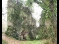
Also on privratnoy Square, next to a defensive wall, the ruins of a mosque, erected
in the first half of XIV century in the Old City. On the contrary it stands the octagonal mausoleum in terms of (dyurbe) under a tiled roof pavilion. This tomb was intended for the daughter of Khan Tokhta-Mouse Janicke Khanum, who died in 1437. Inside the crypt is installed headstone with an inscription in Arabic, in which Janicke called "the great empress."
In the north-eastern edge of New Town, in the bottom tier of a two-storey cave complex, a prison. Far from it are the ruins of the baths, built at the end of XVII - beginning of XVIII century.
From the northern edge of the plateau, click on the cross street to the south. On the main street of New Town, which runs from the gate Orta crow to the east gate Bink-crow, is a well-preserved residential mansion of the XVII century. She belonged to the Karaite scholar A. Firkovich (1787-1874), scholar of history, language and customs of its people.

In the Karaite kenasa estate and A. Firkovich today operates etngrafichesky center "Cape." The center hosts exhibitions devoted to the culture and life of the Crimean Karaites, Karaite traditional cafe food.
After seeing the estate of A. Firkovich, return to the South Gate. On the way to it there is a unique collection of Karaite houses of worship - kenasa. The complex is a small courtyard, enclosed by a stone fence.
Coming out of the city through the southern gate, turn left and walk along the path along the foot of the plateau towards the eastern gate Bink-crow. From them, the road goes to the cemetery in Iosa-fatovoy Valley.
Cemetery - a shrine of Crimean Karaites and, moreover, a valuable historical
cal monument. There remained several thousand tombstones with epitaphs in Hebrew. From the South Gate on the road already familiar to you can go back to the Assumption monastery.
Inspection of the cave city of Calais can be combined with a trip to the Tepe-Kerman.
Coming from Calais through the Eastern Gate (Bink-crow) and going down into the valley of Jehoshaphat, follow the walking trail that runs along the ridge through the forest to the south .. Distance - 1.5 miles. Before reaching the summit of Mount Calais (not to be confused with cave city!), Turn left, walk down the ridge into the gorge and then walk along the pedestrian path to the south. The road leads to the foot of the mountain Tepe-Kerman, which has a conical shape, with the northern slope. Here begins the ascent to the plateau. Distance - 1 mile.