Cave Monastery Chilter-Marmara
the time allotted for inspection tourist facility for 2-3 hours
Getting there
From the cave town Eski-Kerman
- From the Eski-Kerman need to go south on ravine Bilderan. Distance - 1.5 miles. The forest road takes you to descend from the plateau Chilter-Kai. Going down to the foot of a rocky cliff, turn right and move along the steep walls. After about 1 kilometer trail leads to the foot of the cave monastery
- From Cave City move to the north-east to the village of Red Poppy. Distance - 9 miles. From the village of Red Poppy, follow the road, T May 1 in the direction of the village Ternovka. At the entrance to Ternovka do not turn right onto the road leading into the village, and Drive direct, past the greenhouses until the paved road will not go to sidetrack. Here it is necessary to leave the car and then climb through the pedestrian trail to the rocky cliff of Mount Chilter-Kai. Distance-13 miles.
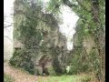
Cave Monastery Chilter-Marmara (from the Tatar "chilter" - "lattice" and Marmara - the name of the medieval village, situated in the vicinity of the monastery) is located in the cliff rocks Chilter-Kai.
Caves Monastery are located in five tiers, which are connected by a ladder transitions. In the cave complex includes 80 rooms, 56 of which have survived quite well, including living cells, auxiliary buildings and four churches.
The first cult cave constructions appeared in the hillside Chilter-Kai in XII-XIII centuries. In XIV-XV centuries, the monastery experienced a boom extended and richer. After the capture of the Crimea by the Ottoman Turks in 1475, the monastery fell into disrepair.
Rise from the highway to the monastery on the trail that will lead to the lower tier of the cave complex. In the eastern part survived 12 artificial caves, and in the west - two of natural origin. The caves were used for household needs.
Monastic caves from second to fifth floor are an ensemble and have a common-gate course on the eastern edge of the second level. To her from the foot of the cliffs are a step
carved into the rock ladder. Climb up on it on the second floor of the caves. A large part of this tier of caves used for commercial purposes. In the middle of the second level is a staircase leading to the other tiers.
The central place in the second tier is a large natural grotto, which is supported by a set of five columns. In the eastern part of the cave there was a church. In addition to the church, located in a cave winery. In the rock hewn tarapan, next to which is well visible slots for the installation vessel.
Caves of the second tier stand out for its size. Most of them are used for commercial purposes. It also cut down five egg-shaped containers for collecting rainwater. Their depth - 2-2.5 meters.
Further up the stairs in the central part of the complex go up to the third tier of> which consists of residential, isolated areas. The extreme west room had two windows and a deepening along the north wall to install the benches. Perhaps it was a monastery sacristy and library.
Next on the hidden passage in the rock go to the level of the fourth tier. You will be taken in three interconnected caves. In one of them. (Room with a recess in the floor and blackened the walls), perhaps there was a bakery.

The fifth tier, in fact, located on the surface of the plateau consists of two caves - the artificial and natural. Perhaps, in a karst cave once inhabited monahotshelnik, in whose memory this chapel was built. On the fifth tier of the main gate of the monastery were. They were turned in the direction of the plateau and is located north of the Marmara Chilter-settlement of Eski-Kerman.
The cave complex in the vicinity of Chilter-Marmara
By Chilterskomu monastery probably belongs, and a small cave complex a mile east of the monastery. Here in the rock carved doorway and a staircase of 14 steps. Climbing up on it, we get to the platform in front of a natural grotto quite large - 5 to -20 meters. In the east wall are the ruins of the apse and the altar. Apparently, there was a hermitage hermitage.