Cave city Buckle.
the time allotted for inspection tourist facility for 1-2 hours
Getting there
From Simferopol
- From the railway station by train Simferopol - Sevastopol should reach the platform in 1479-km (p Pleasant Rendezvous). Then - go on foot along the highway to the village robin. 2 km. Passing through the village, turn right onto a trail, go across the river Alma, and go south. The road will lead to the northern end Baklinskogo plateau.
- From Simferopol bus station by bus Western "Simferopol - Scientific" to get to the village of Rocky. Next, take the dirt road to the southeast. Pass through a small grove and orchard. The road will lead to the ridge Buckle, which is located the same name and settlement. Distance - 3.5 miles. Another option - from the village, take the rocky road to the south-east towards the village of Science, a monument to soldiers of Alma guerrilla group. Distance - 3 miles. From the monument, take a left and follow the road along the slope of the Internal ridge on the paved road. Leaving the right kamnepererabatyvayuschee company (a few buildings behind the fence), drive on a dirt road that runs along the edge of the field and along the forest edge. The road leads to the foot of Mount Buckley. Next you need to climb up a steep slope to the southern entrance to the plateau - a cleft in the steep rock wall. Distance - 2.5 miles.
- On the route Simferopol - Sevastopol (M 26), follow to the village Novopavlovka, located on 11th kilometer of the highway. Then, take the motorway T January 16, leading to the village of Science, having passed the village of Rocky and before you reach the village Trudoljubovka, turn left onto the paved road. Leaving the right kamnepererabatyvayuschee company, take the dirt road that leads to the foot of the plateau Baklinskogo. The car can be parked in front of a barrier.
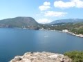
Cave City is located on a vast Buckle Plateau, south and east is limited to 15-meter rocky cliffs, and from the north and west is surrounded by limestone ridges. The area of the settlement, occupied the plateau and undeveloped hillsides, was 20 acres.
Buckle leads the cave cities of Crimea by the number of detected grain pits. Here they were more than a hundred. Stocks of grain contained in the tanks, obviously exceeded the needs of small population Buckley. According to one version, the city kept a strategic stock of grain for the population of all the surrounding valleys.
A small settlement appeared to plateau around the IV century. At the initiative of the Byzantine administration Taurica, in the VI century, part of the settlement was surrounded by a defensive wall and into a small fortification. At the same time on the hill south-east of the ledge Baklinskogo plateau was built castle - the residence of the ruler of these lands. In the VIII century castle occupied the Khazars, who subjugated the local population and ruled the territory for many centuries.
The period of greatest prosperity Buckley considered XIII century. The city acted in several Christian churches, developed agriculture, wine making, pottery. At the end of XIII - the beginning of the XIV century it was invaded and devastated by the troops of the gold-Horde Nogai Temnik, then life on the plateau gradually faded.
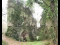
Inspection of interesting objects, preserved in Baklinskom settlement, it is better to start from the south-western extremity of the plateau. On the approach to the ancient settlement are the ruins of the burial complex that included ground-based Church of X-XI centuries. Following along the edge of a cliff, you will fall in western Posad. In a rocky cliff are caves, which are clearly visible inside the carved trough for cattle, niches for lamps and carved in stone grooves for fixing wooden frames and door hinges.

Further, where the trail edge of the cliff and make a sharp turn to the right, is a vast economic area - the old granary. From him walk on the edge of the plateau to the remains of the wine of the complex - the two adjacent tanks of varying depths. Next to the tanks are four burial pits and hatch in the lower tier of caves. Not far from the wine cave complex begins at the south entrance corridor Baklinskoe plateau. On it you can go down to the bottom of a rocky cliff. Turn right and move along the wall towards the western tenements, you will go to the source. Here you can quench your thirst and to collect fresh water.
From the source back to the plateau and turn right. Along the path you will go to the site of plateau once housed the citadel of Buckley. Citadel of the city, located in the center of a house of the ruler and the church was enclosed by a wall. In the northern corner of the building was a rectangular tower, covered the entrance gate.
From the citadel in eastern Posad can be reached through a tunnel carved into the rock. After going through it, you will go to the site, fenced off from the cliff carved in the rock wall. Visible at the site uncovered during the excavation of the foundation of the cruciform church of X century. On the eastern side of the temple grounds you can see the apse where the altar was placed.
Then move along the edge of the cliff to the remains of the largest in
Buckley granaries. Archaeologists are counted 110 vnutriskalnyh artificial containers. Next to the granary, there are 4 Tarapov-on, 2 cellars and 16 graves. Slightly to the left of the economic complex is the entrance to a cave temple XI-XIII centuries.
In the depths of the plateau to the north-west of the city's major buildings in the limestone hillside you can see the number of artificial caves. Presumably, this was located outside the town of Convent, but survived to this day the cave served as hermitages.