Cave city Kachi-Kalon
the time allotted for inspection tourist facility for 2-3 hours
Getting there
From the cliffs of Tash-Air
- Once, visiting cave paintings move in a southeasterly direction to the foot of the rocky massif Kachi-Kalon, where you can leave the car and start hiking ascent to the cave complex. Distance - 0.5 miles.
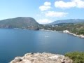
Cave city Kachi-Kalon (in translation from the Tatar "crusade ship") is located on the western slope of Mount Fytski in the rock mass, located on the right bank of the Kacha.
Rock mass Kachi-Kalon in approaching it from a giant nose reminiscent of Bakhchisarai ship, hanging over the valley Kaminskaya. This similarity, noted by the ancient inhabitants still surrounding valleys, gave the name of the cave city. On the flat nose cut off the "ship" is easily visible a huge cross. It was formed by wind and water, giving the limestone massifs bizarre forms.
Small rural settlement appeared in the valley of Kacha about VI-VII centuries. In the XII-XV centuries near the settlement was founded a monastery, which lasted until the capture of the Crimea by the Ottoman Turks. In 1851 the territory was handed over to the medieval settlement Dormition Skete. In the early XX century, there emerged the courtyard of the monastery of the Assumption - the monastery of Saint Anastasia, which was closed in 1921.
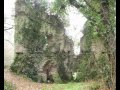
All the monuments are grouped around five villages of the natural rocky grottos. Man-made caves connected by a terrace and stairs, right up to him adjoined wooden buildings.

At the edge of the highway begins the ascent, breaking that you go to the foot of the Northern Cape Kachi-Kalonskogo array. Here is the first cave. Approximately 1.5 hectares of land around it was surrounded by a defensive wall. Inside a protected area located farm buildings and a small cave church of Hagia Sophia, the occurrence of which belongs to the XI-XIV centuries. Next to the temple can be traced the remains of an ancient cemetery. The temple functioned until the end of the XVIII century and was then rebuilt in 1888. In 1921, with the closure of the monastery of Saint Anastasia, and emptied the church of Hagia Sophia. In recent years, church services are held occasionally.
Immediately after the first, begins five-tiered grotto cave complex, which stretches to the entrance of the second cave. Near the second Trot is
block of seven caves, within which felled many niches, shelves and recesses. What are these caves were used, so far not been elucidated. If we move in that direction, then you will go to the third grotto. Its upper level is an ancient temple complex. Here are the ruins of three Christian churches. In the lower tier of the Third grotto in which you can descend the steep stairs and found traces of the wine industry.
The fourth cave, located east of Third mainsail is the most impressive part of the Kachi-Kalona. Here is located the center of the medieval monastic cloister. Of clefts in the northern corner of the cave oozes water. Once there beat the mighty stream that supplied drinking water to the monastery. Today, this source is revered as a holy place and is named after St. Anastasia.
Results in the cave there are about 30 caves, most of which are in two tiers. In the central part of the niche remained phot crumbled caves third and fourth tiers. Longlines. connected by a wooden ladder and mounted platforms.
Before entering the cave is a vast playground. From the southeast, southwest and west it is bounded by cliffs. From the north-west access to the site blocks the line of the defensive wall, the occurrence of which belongs to the XIII-XIV centuries. On the site are clearly visible traces of the cemetery, belonging probably to the monastery, located in a cave, and the ruins of buildings.

In the Fifth inaccessible cave known for more than a dozen caves. To the east of Fifth grotto below the hill, there are a number of cave structures and the remnants of 15 tarapanov - medieval device for squeezing grape juice from the berries.
Grotto of the Fourth on the trail you can go down to the highway. On the hillside at the foot of the grotto in the rock fragment is preserved carved apse of the church of St. Aiastasii. The walls of the church were built of stone blocks. Until this day they have not survived.