Cave city-Kiz-Kerman
the time allotted for inspection tourist facility for 2-3 hours
Getting there
From the cave city of Tepe-Kerman
- At Mount multiplying Tepe-Kerman, with his back to the top, turn left onto labeled trails. Moving along the trail that runs along the gully between the tops of Calais and Kiz-Kul-breaker and gradually turns to the north, exit at the foot of the mountain Beshik Tau. Here you need to turn left and go south. The trail takes on a plateau Kiz-Kerman. Distance - 3.5 miles.
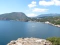
The Settlement Kiz-Kerman (in translation from the Tatar "Maiden Castle") is located at the top of the Cape of Kiz-Kul-breaker, hanging over the valley of Kachin. Kilometer plateau about 200 meters wide at its narrowest point (130 meters) partitioned defensive wall. Inside the protected area was built up area and a vacant lot, where, if the threat of war could shelter the population of the surrounding valleys, with their property and livestock.
Settlement on the plateau of capes in the valley of Kacha was founded in the second half of VIII century the Khazars.
they enter in South West Taurica. At the same time the settlement was built around a defensive wall. In the middle of the IX century, after the Byzantine Empire regained its territory and influence Nahdat founded here femu Climates, people gradually began to leave the settlement, as the new Byzantine administration did not need this reinforcement. Around the XIV-XV centuries are operated small Christian church, which ceased to exist after the capture of the Crimea by the Ottoman Turks.
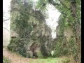
Overcoming rise to the mountaintop Kiz-Kul-breaker, walk towards the western cliff of the plateau. On the western slope of the mountain in 1989 found traces of a small medieval Christian church. He was placed on a natural terrace. The appearance of the temple is tentatively attributed to the XIV century. At the end of the XV century it was destroyed, and more recently people from nearby villages used the stones from the ruins of a temple for new buildings.
The walls of the church were two-layer, the space between them filled with small stones. From inside the temple walls were plastered. Not far from the church showed signs of graves.

From the ruins of the temple move in the direction of the southern cliff of the plateau. Short of a hundred meters up the shaft of stone that marked the boundaries of the ancient settlement, you will see pronounced traces pozdneskifskogo Selishche that existed on the plateau in the I century BC. Oe. - III century AD. Oe.
In places where the stone wall discovered during archaeological investigations, are the ruins of the defensive wall. It consisted of three curtains and two towers. At the eastern edge of the wall traces of the gate and the west - the traces of the gate, beside which was a descent from the ancient settlement in the valley.
Go to the defensive walls of the adjacent territory, in the past built up large estates tightly. At this point plateau Kiz-Kerman found seven such farms, which suggests that the number of Lost yannogo settlement population was 60 ~ 80 people. Near the remains of homesteads tarapanov.
In the southeastern part of the plateau was the residence of the governor - the building, consisting of several rooms.
On the territory of Kiz-Kerman found only three artificial cave. First served tsister
Noah and was located inside one of the estates. The second was on the southern edge and a patrol. The third cut down on the eastern slope in front of Tepe-Kerman.